

TThe smell of limestone fills the air as a coastal wind moves around the Grobnik Alps, making the landscape feel alive. Named after the Grobnik valley below, this Croatian mountain range is made up of bold peaks and hidden passages. Mudna Dol canyon is one of the most memorable ways into this rugged area. The massif rises above the fields near Rijeka, creating a natural border between the mountain interior and the coastal Mediterranean.
Dense plants, steep rocks, and narrow passages quickly pull you away from towns and into the wild. Mudna Dol is not just a way to enter; it is a transition. Here, the land closes in, the air feels different, and the mountains make themselves known long before you see their tops. When the last sounds of people fade, you leave behind the daily noise and hurry. In this quiet, your mind slows and focuses only on the path. This trip is not just about walking; it wakes up senses dulled by habit. You notice the wind, changes in light, and the earth under your feet. To enter the wild here is also to connect more deeply with yourself.
If you have driven through Grobnik Field in Croatia, you have probably seen the tall peaks of the mountain range above Rijeka. This range, called the Grobnik Alps, separates two worlds. To the north is Gorski Kotar, a mountain region inland. To the south, the lower slopes reach the Adriatic Sea above Kvarner Bay.
The reasons why you should hike it
Many travellers see the Gorski Kotar mountains only as a quick view from the car while driving between Rijeka and Zagreb or heading to Istria. Dark forests and rocky peaks pass by in seconds. By skipping these mountains, people miss out on a place that can help them connect with nature and find peace. This area is a hidden gem, full of beauty and perfect for anyone wanting to slow down and enjoy the outdoors. Hahlići, in particular, is often overlooked and deserves more attention.
Whenever I wonder why someone should hike here, I find the answer as soon as I start walking. Those who love adventure are drawn to the Hahlići Lakes, while those seeking something wilder can climb through the Mudna Dol canyon. This article focuses on that route. I have hiked the canyon many times, even during mountaineering school, but my first trip as a boy with my father stands out. I remember his steady hand on my shoulder, giving me courage. Whenever I slipped, he was there, patient and calm, teaching me to watch my steps. The wind seemed to carry old stories, and for the first time, I felt the mountain’s presence. That hike became a rite of passage and a memory I will always keep.
Mudna Dol is special because it combines hiking and climbing in a narrow canyon unlike any other in Croatia. Intermediate and expert hikers enjoy the exciting views along the Istočni greben (meaning the Eastern Ridge), while beginners can relax on the easier trails near the Hahlići Lakes, where the calm and quiet help slow things down.
But this is only the beginning. Each trail to Hahlići has a different pace, challenge, and quiet spot. Every path has its own story. I will tell you about each one in future guides. Hahlići is somewhere you visit more than once, and no single path can show it all.
Hiking directions
Between the tall white peaks, you’ll find a mix of meadows, forests, rocky spots like Pakleno, and quiet ponds. Mudna Dol Canyon welcomes hikers into this wild area. In the middle is the Hahlić mountain lodge, a peaceful place that feels like the old alpine shelters that inspired the Grobnik Alps’ name. Here, you can truly connect with nature and enjoy Croatia’s untouched beauty.
Directions to reach Hahlići:
1. Preko Kolci: a well-marked hiking route that is quick to follow.
2. Preko Čeke: a clearly marked hiking route that is also straightforward.
3. Istočni Greben: moderately marked Hiking Route.
4. Mudna Dol canyon: the most attractive but also the most challenging and potentially dangerous hiking route. For this route, bring a helmet and harness, as there are exposed passages that require extra caution and basic climbing skills.
5. Podkilavac – Mudna Dol (or Istočni Greben) – Fratar – Hahlići: this varied route combines several trails, often used in dry weather for hiking between Podkilavac, Mudna Dol canyon or the eastern ridge, Fratar peak, and finally Hahlići lodge.
Starting point: Podkilavac village is the most commonly used starting point for Grobnik Alpshike
The most common starting point for various trails in the Grobnik Alps is the village of Podkilavac. Surrounded by traditional stone houses, this small village marks the beginning of several trailheads to the Hahlići mountain lodge. Each path from Podkilavac varies in steepness and length, but all eventually reach one of Croatia’s most beautiful lodges.
Access to the starting point (Podkilavac):
🚗 By Car: When driving on the Rijeka-Zagreb highway, take the exit at Čavle junction. Join the old Rijeka-Zagreb road, turn right at the traffic lights, and follow signs toward Donje Jelenje-Dražice. Pass through Dražice village and at the roundabout take the second exit, marking the start of hiking routes to Podkilavac. There is a supermarket in Dražice for last-minute supplies.
Stay on the road heading toward the mountains, passing through Podkilavac. After 2.5 km from the Dražice roundabout, you’ll reach the Zala stream bridge at Rastočine. Podkilavac is where most ascents of Hahlići and other peaks in the Grobnik Alps begin. At the parking lot near an old oak trunk is an info board showing signposts and walking times to each destination.
Beyond the bridge, continue for about 5 km, keeping left. You can also reach the lodge by forest road via Klana, Gumanačka, Trstenik, and Suhi, which takes about 1 hour. Note: The road is rough (macadam), so only off-road vehicles should use it.
🚌 By bus. The Autotrolej public bus line connects the village with Rijeka. Check the timetable here (Croatian). The bus turnaround is only 100 meters from the start of the hiking trails.
Hahlići – Fratar Peak via Mudna Dol Canyon trail description
The route begins in the tiny village of Podkilavac, first crossing wide pastures before entering the narrow Mudna Dol Canyon. After less than two hours of hiking, the trail opens onto forested meadows, gradually transitioning to rocky pathways that lead to Fratar Peak. From the summit, the descent continues toward Hahlići Mountain Lodge, passing “Kolci,” before returning along the ridge to Podkilavac.
This beautiful mountaineering climb follows the naturally long gorge of the Sušica Stream in the Grobnik Alps. The canyon can only be safely traversed in dry weather; during rain, it floods the Grobnik Field, making it impassable. The trail combines wide-open pastures, forested slopes, and the dramatic narrowness of Mudna Dol, offering a complete experience of the mountains’ variety and rugged beauty.
1. Podkilavac –Mudna Dol
The ascent starts in the tiny village of Podkilavac by crossing the bridge over the Zala Stream, and continues to the right on a macadam road, followed by a road to a meadow. Since the easier route to the mountain lodge splits to the left at the checkpoint, consider continuing straight at that crossroad. This whole area is called Ravno “Grobničko polje” (Flat field of Grobnik), meaning that there is almost no ascent on it, so it is suitable for warming up. Below, the hiking trail leads along the dry bed of the “Sušica stream” to a wooden board on which it is pointed out that one enters Mudna dol.
Sušica collects all the surrounding streams that spring at the end of Podkilavac (Zala, Rastončica, Borovica, Tomažina, Mudna, Kacaj). These are all tributaries that dry up most of the year. The streams Gonjuša and Lužac also flow into the Sušica stream. The stream Užac, when it passes the place Jelenje, is also called Rupa – Podrupac. There is an immense abyss on Rupa that swallows all the water. The first stream to appear after heavy rains is Lužac, followed by Zala, Sušica and Gonjuša. Lužac starts first, and the last one stops flowing. If a hiking trip is undertaken after heavy rains, one should consider this.
When it turns into the gorge of the Mudna Dol stream, it begins to take on more exciting shapes, while the feeling of wildness becomes more and more pronounced with each step.
Mudna dol canyon: The owner of the stone
After about twenty minutes of walking from the gorge entrance, you are faced with its first true temptation: a ten-metre-high vertical rock step. A dozen metal wedges and rather loose steel stairs have been installed to make this natural obstacle easier to overcome. They do not inspire complete confidence. For full security, a short self-insurance rope is recommended, though experienced hikers often go without it. Some of the steps are visibly bent, offering less than perfect footing — yet the simple fact that these stairs have been here for decades brings a strange, quiet reassurance.
Standing here always pulls me back to my first visit. I came to this place as a boy, walking beside my father. Back then, I had no real sense of attachment to nature, at least not in the way I understand it today. I had no climbing skills, didn’t even know that mountaineering clubs existed. I believed that hiking and climbing were things other people did, not us.
And yet, even then, I knew we were standing inside something vast and powerful. An impressive canyon, revealing its strength for the first time. This was perhaps the moment I first truly encountered a challenge — one that did not merely look dangerous, but genuinely was. A single mistake here would not be forgiven.
Still, we continued upward, step by step, trusting the cold steel beneath our boots. Can you imagine it? By all formal classifications, this route is still considered A-standard — summer mountaineering. And yet, in that narrow throat of stone, with the canyon tightening around you, it feels like far more than a simple walk.
One should carefully ascend this obstacle, taking it “step by step.” At the top of the cliff, at least one more wedge as a handrail would come in handy. Keep your hips close to the wall on the final rung to maintain balance and ensure safety. One should accept the situation that there is no wedge flow, and the four-legged climbs to the solid ground under their feet.
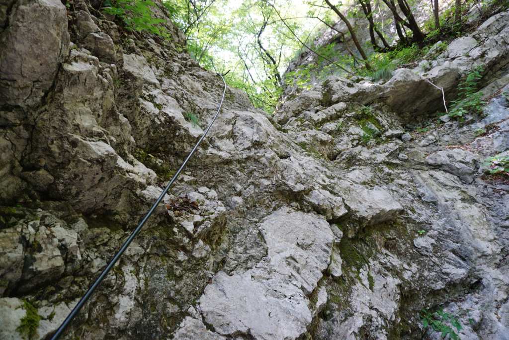
The continuation of the ascent would be too magnificent for climbing lovers. The pathway will lead you through a narrow stone trough with large smooth-walled oysters, hollowed out by water affluents, after you reach a new obstacle. To be overcome with the help of a steel sail, head the top of oysters. The look back into the depths of the oysters of this masterpiece of water power is truly phenomenal. However, there is still a long way to go before climbing the new, exciting rocks. It hangs out with a series of rocky shapes on this climb, so this whole story is reminiscent of a small but real mountaineering tour.
The ascent is quite strenuous because about 2 kilometres must be covered to overcome a height difference of about 500 meters. The effort required to overcome this ascent is quickly forgotten. The wild nature and many different stone shapes remain in memory. This ascent is unique. The only one similar to it in Croatia is the one that runs along the Mala Paklenica riverbed (Paklenica National Park). There is another large oyster that fills with water during the rains, and just above it is the checkpoint of the “Hahlići Hiking Trail”. In the metal box is the registration book, without the mountaineering stamp.
After that, you enter the narrowest part of the gorge, where the distance between the walls is reduced to 1-2 meters so that the sun’s rays can rarely reach this part of the canyon. Mudna Dol offers few rest opportunities; you should continuously climb with your feet and hands, both on cables and off. Take a moment to halt, silence your thoughts, and pay attention to the echoes that bounce softly from one stone wall to another. Let this natural resonance guide your breaths and slow your pace, mirroring the rhythm of the hike itself. When you reach a small extension with beech trees, you enter the tame part of Mudna dol.
2. Mudna Dol – Fratar peak
Continuing the ascent, the magnificent gorge’s wilderness gives way, and the hiking trail climbs the grassy slopes to the intersection with the path from Platak to Hahlić Lodge. At this crossroads, turn left and continue the ascent along the foot of the Fratar all the way directly to the mountain lodge on Hahlić (1097 m). There are crossroads where you should turn left onto the beech forest trail. Upon entering the forest, it immediately becomes clear that the ascent to Fratar is not at all easy. The reason for this is a more severe uphill that made climbing much more difficult.
Due to the rugged terrain with many rocks and ravines, the ascent to Fratar in normal conditions requires a dose of caution. Coming out of the forest below the top, you come to a bare rocky ridge, from where there are still ten minutes of pleasant ascent by a rock to the top. From the hill, sweeping views open up to an enjoyable environment in which the neighbouring “Suhi Vrh” is particularly striking. The Fratar Peak (1353 m) has a regular cone and is the most striking top of the whole group.
The top rocky head seems to emerge from the juniper’s dark belt that blankets Fratar Peak. Being closer to the sea than the Hoop, it offers terrific views in all directions. The summit is marked by a stacked pile of stones with a wooden stake rising from its centre. A few metres below, a metal box holds a registration book and a mountaineering stamp — the HPO trail stamp, ready for those collecting the Croatian Mountaineering Path, or simply for anyone who likes to leave a quiet mark in their own personal hiking diary. The stamp marks Fratar Peak as part of the HPO (Service of the Croatian Mountaineering Association trail), a quiet reminder that this summit is woven into a much longer story of Croatian mountaineering paths and journeys.
3. Fratar – Hahllići
The gentle marked pathway will bring us descending to the mountain lodge Hahlići in some 45 minutes of walking. The way runs through the beech forest. Eventually exits at the meadow to crossroads showing the indications leading to the mountain lodge.
4. Hahlić Mountain Lodge & Lakes
Hahlić mountain lodge (1097 m), built on a tiny ridge between a pine forest and a rocky head, has been freshly renovated. It is equipped with electricity, cameras and the internet. The lodge is open on weekends. Situated in a small valley between the peaks and Ćunina Glava Peak in the shade of mountain beech and spruce, the home seems to be copied from those of the real Alps. As the day’s adventures wind down, imagine gathering on the lodge’s terrace, basking in the warm glow of a shared sunset. With hot tea or coffee in hand and the stunning views of Kvarner Bay and the distant mountains stretching before you, this shared moment creates a connection beyond individual challenges. It’s a time to reflect, celebrate achievements, and plan the paths yet to be explored, turning individual trails into a shared journey.
The lodge, tucked into spruce and beech forests, opens to the Bay of Rijeka on the front and terrace. So with hot tea or coffee, you can take a break in the sun, enjoying a view of Kvarner Bay and the nearby mountains. With a little luck and the right timing, you will spot wild horses on the endless meadows. In addition to the pastures, the horses used to drink water from the lakes. “The mountain lodge should be opened every weekend, no matter what the weather is. Both in the rain and the snow, and the worst is in a fog. At the same time, you don’t see anything in front of you” – it tells us the lodge superintendent as we warmed ourselves around the fireplace.
The mountains that stand out like the snow pyramids on the horizon, due to the grassy areas, become incredibly photogenic during winter. The mountain ridges and peaks used to be covered by snow; however, the magnificent views of the sea and the land are now available. However, winter conditions also carry their dangers, so the caretaker warns that one should take the mountains seriously. In summer, because of the heat, and in winter, because of the snow and ice. Unfortunately, mountain rescue service interventions are not uncommon. “I had to call them once myself,” the janitor told us. “You stand wrong, twist your ankle, and that’s enough to require help since you can’t go half a meter on your own.” Luckily, Croatia’s mountain rescue service is one of the best in the mountains, so when things go wrong, we’re used to being in good hands,” a janitor also said. “Yet this does not mean that one should be irresponsible and ill-prepared to challenge fate”, the janitor also added.
The lodge is set in the highest peaks of the Grobnik Alps range, from the highest peak, Obruč (1377 m), and the picturesque rocky peak Fratar (1358 m), to Pakleno Peak (1340 m), Osoje Peak (1338 m), and Suhi Vrh Peak (1250 m). From Hahlić Lodge, it is possible to further climb towards the top of Fratar Perak (1353 m), which you will need a little more than an hour to do. They call it the most striking peak above Hahlić, and from a distance, it is clear why: bare stone peaks rise above the wooded slopes that have now taken on a whole range of autumn colours.
From the lodge, continue towards Suhi Vrh, Ćunina Glava or even further. If you are on a day trip and catch a return before sunset, it is best to descend towards Podkilavac along a path that leads through a grassy valley and past picturesque rocks.
5. Descent: Via Kolci (The way “over the stakes”)
A few minutes’ walk or a hundred steps from Hahlić mountain lodge (1097 m) are the three ponds, standing next to each other, walled with dry stone walls. The locals call them Kalići, Hahlići, hence the name of the whole area. From the ponds, get straight to the crossroads first. According to the prominent signposts, corners are possible to descend in two ways: “easier way” and “steeper” – over the poles. So it would be best if you chose the “steep” saddle, which offers a fantastic view of the seacoast and Učka Mountain.
This part of the descent to the saddle could also be made via “Ćunina Glava” Peak, but it is a little sharper and more tiring. In the continuation, the hiking trail leads from pole to pole, a little more pointed downhill on a grassy slope, with endless views of Grobnik Field and the sea. After the wooden stakes, which serve as a landmark, the whole trail got its name – through the stakes.
The lookout is followed by a more laid-out dirt path to a rock, where a cable secures the passage. Then it descends along a rocky slope and eventually passes through a screen into the pine woods. From this point, the hiking trail turns right with a sharper ascent through a pine forest to a landscaped rest area. At this lookout point, there used to be a rest bench destroyed by the ravages of time. Below, the hiking trail follows a gravel road to the end, where there is a turnpike for the knot. From that point, I suggest turning left over the ridge. The non-marked but excellent pathway leads down over the ridge, extending magnificent views. Finally, the path winds us back to Podkilavac village, gently closing the circle around Fratar Peak in the Grobnik Alps.
Conclusion and technical gain
The day lingers in memory — a unique hiking adventure that is as captivating as it is demanding. Along the way, Mudna Dol canyon leaves its mark: a monument of wild, untamed beauty, with narrow riverbeds, steep cliffs, and unusual rock formations that remind you how alive and unpredictable the mountains can be. Each step through its passage echoes the thrill of discovery, the hush of the wilderness, and the quiet satisfaction of a journey well completed.
⛰️Highest point/summit: Fratar: 1353 m
⏱️Duration: 6.30 h (4 h ascent, 2.30 h descent)